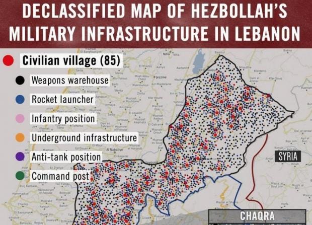
Israeli Defence Forces (IDF) have defended sharing an inaccurate map of Lebanon annotated with Hezbollah military positions and warehouses, saying the map was for “visual illustration” purposes.
The official IDF Twitter account posted the map titled “Declassified map of Hezbollah’s
military infrastructure in Lebanon” on Tuesday, highlighting more than
80 towns and villages and thousands of spots it said were home to sites
such as rocket launchers and infantry positions.
“This is a war crime,” the tweet’s caption said, alongside the tagline “Hezbollah’s hiding behind Lebanon’s civilians.”
It was shared hundreds of times before one Twitter user
pointed out that the picture couldn’t be a declassified military map
because the image’s history showed it been created using Google Maps by
an IDF spokesperson account, and featured repetitive patterns.
The map – which according to the Times of Israel
was construed as an IDF attempt to build a case for future military
action and demonstrate Israel’s sophisticated intelligence-gathering
capabilities – was shown to foreign diplomats visiting Israel, local
television reported.
When asked for comment, the IDF confirmed that the map is
inaccurate, calling it in effect “an illustration of what is going on in
Lebanon”.
“The illustration reflects how Hezbollah has positioned its
terrorist infrastructure within the civilian arena,” a spokesperson
said.
The IDF has used social media extensively in the last few
years as part of a hearts and minds campaign to combat terrorism carried
out by groups hostile to Israel such as Hezbollah and Hamas.
Israel has attacked two Hezbollah sites in Lebanon in the
last two weeks, the militant movement claims. Israel has not confirmed
or denied its involvement.


